The Connecticut Trail Census facilitates the collection and use of two types of data: count data (# of uses) and intercept survey data (user behavior).
-
- Intercept survey data is collected by volunteers who conduct surveys intercepting trail users.
- The survey consists of multiple choice and open ended questions on a variety of trail use topics such as distance traveled to use the trail, primary reason for using the trail, and demographic information about who is using the trail.
2020 Data Collection
- Due to COVID-19 Social Distancing mandates, the face-to-face on trail intercept survey has been suspended until further notice. The survey will be deployed via QR codes to all trail sites by May 1, 2020.
- 2020 QR Survey Participant Information Sheet About this Study
Aggregated Data Reports
2020 Aggregated Survey Data Report
April 22, 2021This report provides a summary of intercept survey data collected from multi-use trail users by volunteer surveyors at sites participating in the 2020 Connecticut Trail Census. This data was collected through 1,372 surveys by respondents to a QR based survey deployed through posters and lawn signs from April 9, 2020 – December 31, 2020. trails throughout the state starting on for analysis in this report. it provides a general picture of those surveyed on these trails and how the trails are being used.
2019 Aggregated Survey Data Report
March 9, 2020
2018 Aggregated Survey Data Report
March 15, 2019
2017 Intercept Survey Data Report
February 12, 2018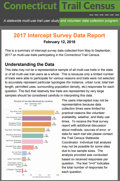
This is a summary of intercept survey data collected from May to September, 2017 on multi-use trails participating in the Connecticut Trail Census. Of the fifteen multi-use trails included in this study, eleven trails provided intercept survey data. The actual site of the data collection was chosen to accurately represent normal trail use along the trail segment. These sites varied slightly from the locations chosen for infrared counts (not included in this summary). This is an abbreviated summary of the data.
Intercept Survey Data Downloads
Please contact Laura Brown laura.brown@uconn.edu for inquiries about the 2019 or 2020 survey data files.
Download the 2018 Intercept Survey Dataset & Charts – Excel (xlsx) file
Download the 2017 Intercept Survey Dataset –Excel (xlsx) file
2017 Intercept Survey Individual Site Reports
Understanding the Survey Data- Key Points
Data should not be generalized
The citizen science based structure of this study creates some significant challenges with regard to generalization and communication of the data collected. The user identified nature of the sampling collection points means that sites selected to participate in the Trail Census may not necessarily be an accurate sample of bicycle/pedestrian trails in the state. Further, given that the data collected represents use within a particular community around a data collection point, the data cannot be used to accurately estimate total use along the entire length of a trail.
Following the pilot period of data collection in 2017, a significant effort was made to identify and reduce the potential sources of error. Because this will never be a fully research based design however, the data should alway be viewed as not broadly generalizable or representative of the full population of trail users. The goals in this review effort were to decrease the margin of error of volunteer administered intercept surveys while also increasing Site Coordinators and volunteers’ ability to successfully administer them.
Read the meta data
Each spreadsheet download on our website includes a “Read Me” tab with information about the data. We encourage you to take time to review this before using the data.
Read more about limitations on the Methods page.